|
The Origin of the Village Name
of IECEA
(Jetscha)
by
Norbert Neidenbach
With permission, translation was
done by Diana Lambing, published at DVHH.org 10 Mar 2004 by Jody McKim
Pharr.
Some
publications
have already
attempted to
explain the
origin of
the name
IECEA.
Several
meanings
were given,
but to me
the most
likely one
was a
derivation
of the
Slavonic
word JECE or
JEC-ATI,
which means
‘to murmur’
or ‘to
rustle’. My
reasons for
this
assumption
are as
follows:
After
the Huns retreated, the Banat was populated over the
centuries by farming people (Gepiden, Geten, Celts and
Slavs) . Although there are not a great number of
Slavonic village names, we can still assume that a large
number of Slavonic villages existed (see E. Moor’s
‘Ortsnamen im Theissgebiet’, page 139). The
increasing marshiness of the ground was tied in with the
desolation of the countryside during the Turkish rule.
Although many of the existing places were abandoned, the
names given to them were kept on, as was the Slavonic
name of the IECEA estate. This ‘murmuring’ or
‘rustling’ points to the existence of a stretch
of running water and as the current hydrographical maps
no longer compare to those made at the beginning of the colonization of the Banat, old maps were used to present
this case.
The
hydrographical landscape of the Banat had far-reaching
changes made during the past 250 years. Firstly, by the
draining of the marshes, then by the establishing of a
road network and later by the regulating and canalization
measures taken during the 1960s. Several former stretches
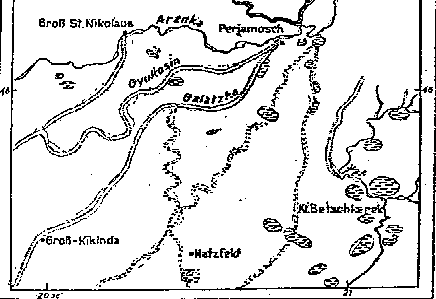
of water can be cited as examples. One of these river
beds, or furrows, branches off from the Aranka near Perjamosch, passes through
Pesak, Lowrin, Komlosch and
Gross Kikinda to the Theiss and is called the Bara Furrow
or Galatzka Ditch. On the 1746 Mercy map of the Banat,
the Galatzka is drawn as a wide river bed; today, the
course of the river can only be seen here and there. The
Jer Ditch is a similar case. This springs up in eastern
Banat, the ditch widens out to a lake behind Knes and
then reaches the edge of Biled via a marshy area, where
it becomes a stretch of stagnant marshy water. The Jer
took up the ground water coming in from Warjasch and
flowed through Klein Betschkerek to Bergesau where it
flowed into the Bega canal with the Bergesau. Because of
the very slight decline of the land, the Jer meandered a
lot and together with the Cserna Bara (Black Water)
formed a stretch of three to five kilometers long (1.5 to
3 miles) to the east of Klein Betschkerek. An extract
from the map ‘K. u. K. militärgeographischen
Karte’, Vienna, taken in 1881, revised in 1912,
scale 1 : 75,000, and a morphological map by I. Cholnoky,
‘Die hydrographischen Verhältnisse der Heide’
(Hydrographical comparisons of the Heath), show large
areas of marshland on the boundaries of the Gross Jetscha
estate, as well as a former river course.
MAP 1

From
I. Cholnoky’s ‘Az Alföld felszine, in
Földrajzi Közlemenyek’, Budapest 1910,
and the
‘K. u. K. militärgeographischen Karte’ from
the Viennese Court Chamber archives.
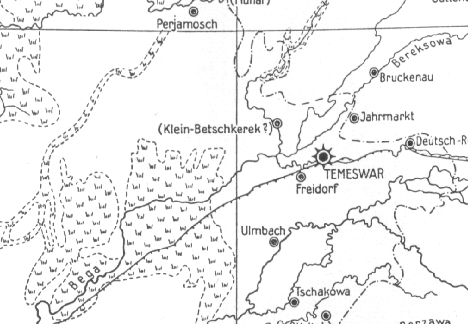
Map 2

From
a map from the Viennese war archives,
‘Bannat-Temesvar,
aufgenommen und abgemessen in den
Jahren 1723...’
there was still an expanse of
quagmire on the Iecea estate.
Map 3

Griselini,
in his ‘Versuch einer Geschichte des...’
describes these marshes in his second letter (letter
number 5 of Part I, and the first letter in Part II) as
‘a vast number of brooks and springs’ along the
Bega and Temesch rivers, comparable to the Pontiscal
quagmires. He cites the formation of these marshes as
being due to the lack of dams along the numerous small
streams south of Aranka.
There
are no longer any traces of a river on the boundaries of
Gross Jetscha, but the water meadows between Gross
Jetscha and Gertianosch imply that this area was once
very exposed to the inflow of water. These ditches were
also part of the Gyukosin Furrow system (the Gyukosin
main collective canal ran from Triebswetter through Nerau, Marienfeld and Albrechtsflur to Gross Sankt
Nikolaus).
To
give credence to the former existence of a stretch of
running water on the Jetscha estate, i.e. to understand
the origin of the name Jetscha (Iecea), later sources
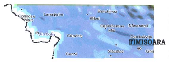
were also consulted. On an internet server I found a
collection of very detailed geological, morphological and
physical maps of European countries (http://www.geo.strategies). On these maps, too, there
are very clear depressions and furrows to be seen in the
Jetscha area which run between Biled and Gertianosch.
Considering
Griselini’s explanation of the formation of these
marshes, the case can be made for the former existence of
a stretch of running water on the boundaries of Iecea,
and therefore also for the origin of the name IECEA.
Norbert Neidenbach
Translated by Diana Lambing
 Gross Jetscha Gross Jetscha
DVHH.org
©2003
Donauschwaben
Villages
Helping
Hands,
a
Non-profit
Corporation.
Webmaster:
Jody
McKim
Pharr
Keeping
the
Danube
Swabian
legacy
alive!
Last
Updated:
25 Jul 2019
|
| |
|