|
History
of Sotting - Sotin
Part 1 |
Part 2
by Kurt McCRARY
4th
Draft January 2004
Sotting
has had many names because of the different languages spoke by the
people who have inhabited the area. The Romans called it Cornac. The
Hungarians called it Zatta/Szatta/Szottin. The Germans
called it Sotting. The Serbians and Croatians called it Sotin (
Sotina / Sotinu, ), Hrvatska and that is the official name today. For
the purposes of this Donauschwaben History we will refer to it by its
German name.
The
village of Sotting lies within a region formerly known as Slavonia,
later called Syrmia. (Syrmien/Srem/Sriem/Srijem/Szer?m) The Romans
called Srijem (Sirmium): "Deliciae mundi" which means "the
world's delights". Today Sotting lies within the County of
Vukovar-Sriem, Croatia. Though the names and borders around Sotting
have changed, it remains where it always has. Sotting is a beautiful
area, and is located on the west bank of the Danube (Danuv) River in
a unique position. Directly in front of Sotting looking west is a
small marshy island, which contains a small natural harbor.
The
harbor partially separates Sotting directly from the main confluence
of the Danube River. The shipping lane passes directly east of this
island. Global coordinates for Sotting are: latitude 45.3 N longitude
19.1 E, with an altitude of 403 ft above sea level.
| Several
Archaeological
digs
have
provided evidence of an early Neolithic Age habitation in and around
Sotting. The Neolithic Age is considered to be the cultural period of
the Stone Age, and is characterized by the development of agriculture
and the making of polished stone implements. There has also been
archeological findings from the middle ages (about 476 to 1453 AD);
especially in the ancient settlements around
Bapska
Novak
(German), Lowas (Lovas),
Mohovo,
Sotting (Sotin), and Wukowar (Vukovar).
The inhabitants
built their medieval homes or huts on hills next to rivers or on
solid ground the homes were made of mud and turf. Near marshy swamps
they built on stilts, and had thatched roofs. |

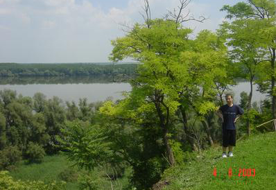
View
of the Danube from Sotting,
photo taken by David Vdovic 2003 |
The people hunted
and fished, gathered fruits and grain. They sharpened and smoothed
stone tools and made others from wood and animal bones and sewed
animal skins for clothing. Later inhabitants developed land and
domesticated animals. They made their own clothing as they were
skillful weavers and like many peoples of the time made clay pottery
for storing food and drink.Sometime before the birth of Christ, a
tribe of people known as the Cornacates (Kornakate) inhabited
Sotting. A village called Cornac at the place of today?s Sotting was
named after this tribe. The tribe was an Illyrianzed, subgroup of the
Scordisci, a Celtic tribe inhabiting the southern part of lower
Pannonia between the Dravus, Danuvius, and Savus. Some authorities
regard them as a Thracian stock, because of their propagation with an
older Thraco Illyrian populace.
In the days of
the Roman Empire, Sotting was considered a strategic stronghold and
the Romans built a good-sized fortress there. This fortress, among
others in the region, formed the Slavonian-Syrmian "Pannonian?
Limes (A fortified border). That protected Roman Settlements from
raids by Barbarian Tribes.In their campaigns, the Romans settled many
other villages, among them: Ilok, Tovarnik and Vukovar. The region
was controlled from the city of Vinkovci, which was known as
"Cibalae". The Romans of course tried to advance
agricultural and were the first to reclaim the banks of the Danube -
which had been mostly marshland for planting vineyards. The Romans
vacated the Danube area after several invasions, first by the nomadic
tribes of the Alanis in the 1st century A.D., and in the 2nd century
by the Goths (a German tribe), and the Huns, about 370 A.D
German-speaking
people first settled around the area about 900 A.D. during the reign
of Charlemagne and his successors. In 1289 Sotting was mentioned in
Hungarian documents under the name of Szata. By this time it was
already a flourishing town. Sotting was strategically situated on the
Danube, an important route. They had a ferry for transporting people
and goods, thus handicrafts and trade were already well developed.
The
presence of the Catholic Church parish in Sotting is documented by
1333 A.D. It is generally considered in respect to the larger area
that many Slavs can attribute a conversion to Christianity that was
led by the brothers
St
Cyril and St Methodius
who
lived in 9th Century.
(http://user.intop.net/~jhollis/cyrilmethodius.htm)
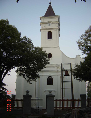
Sotting Catholic
Church, St. Mary's the Helpmate,
photo by Danil Vdovic 2002 |
 |
Sotting and
vicinity was ruled/controlled from Wukowar (Vukovar), in the 14th and
15th century by lords (nobles) like ?Banus Ivanis HORVAT and Stephan
MOSONAC?. Under the Feudal System only nobles owned land. ( Even the
historical names of many officials in the Ottoman Empire reveal their
origin (Hirwat = Hrvat or Horvat, which is a Croatian name for Croat).
The Ottomans
(Osmans/Turks) gained control of the region about the 15th century.
In approximately 1526 to about 1687, under Turkish rule, and a Moslem
majority, Sotting? Catholic community still maintained its integrity,
even thought.
 |
|
After
the Turks were pushed out of Syrmia (Syrmien) and the rest of Europe
in the late 1600's they left an area devastated and depopulated by
years of mismanagement and war. Hence began a large change in
population demographics. Croats, Serbs, and Hungarians began to
reestablish settlements throughout the region. During the 18th
century the "Schwabenzug" or Great Swabian Migration
began. This was the beginning of government-sponsored migration to
repopulate the area with farmers. The sponsors then could maintain
control and generate monies.
Many
Germans because of the economic reasons came forth in large numbers.
First sponsored by Hungarian nobility and later in far greater
numbers by the Hapsburg Emperors, immigrants from the German states
and other parts of the "Holy Roman Empire" were encouraged
to settle in Southeastern Europe. These areas included the Batschka,
Banat, Schwabish Turkei and Syrmia / Slavonia. Sotting's destiny was
greatly shaped by the large influx of these ethnic Germans, later
called Danube-Swabians or "Donauschwaben" after WW1.
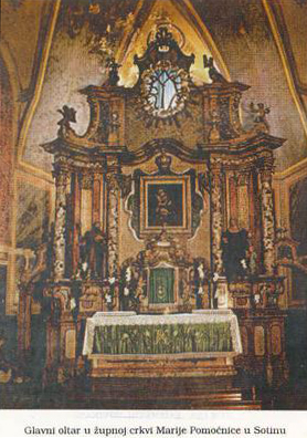
Sotting Catholic
Church, St. Mary's the Helpmate, ornamental altar,
photo from booklet Cudotvorna Gospina Slika U Sotinu |
The majority of
these German settlers arrived in the second half of the 19th century.
German settlements were less common in Slavonia and Syrmia than in
the Batschka and Banat. Though most of the towns Slovonia were not
exclusively ethnically German, according to a 1912 demographic map of
ethnicity, Germans settled in the southeastern parts of Syrmia
(Slavonia) were concentrated around, Franztal, (Siegental) India
(Indjija), Semlin (Zemun), Neu-Pasua (Nova Pazova), Ruma, and
Syrmisch-Mitrowitz (Sremska Mitrovica / Mitrovica), in the northeast
around Esseg (Osijek), Vinkovci, Wukowar (Vukovar). Western towns and
or villages in also in and around Daruwar (Daruvar), Diakowar
(Djakovo), Djurdjanci (Garesnica / Gjurgjanci), Poschegg (Pozega) and
Wirowititz (Virovitica). Other inhabitants included Croatians,
Serbians and Hungarians.
Part 2
|