|
About Banat
The old ("undivided") Banat
comprises
areas of present-day western Romania,
north-eastern Serbia, and southern Hungary, with a total area of 11,013
square miles. It was an Ottoman province from 1552 to 1718, when it
became part of Habsburg Austria. Planned colonization by the Habsburg
emperors brought large numbers of German settlers from the western
regions of the Empire to the Banat.
By 1910 there were
388,000 ethnic Germans (locally
called Swabians, later Danube
Swabians) in the undivided
Banat. By the Treaty of Trianon
(1920) about two-thirds of the
Banat became Romanian; almost a
third became
Serbian/Yugoslavian; only
a small area around Szeget
remained within Hungary.
The Romanian part is centered
around the regional capital of
Temeschburg
/ Temeswar (German) Temesvár (Hungarian), Timisoara, Romania (Official). Other important cities are Arad,
Lugosch/Lugos/Lugoj and Reschitz/Resicza/Resita.
The area north of the city of
Arad, although located north of
the river Marosch/Maros/Mures
also contained a number
Danube-Swabian communities and
is, therefore, usually included
in studies or articles dealing
with the Banat.
Banat
is a region in south-eastern Europe, located
between the rivers Danube in the south, Theiss / Tisza / Tisa in the
west, Marosch /Maros / Mures in the north, & foothills of the
Carpathian mountains in the east. [Nick Tullius]
|
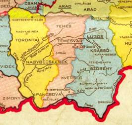
3 Counties of Banat - 1778 |
In 1778, Maria Theresia sacrificed the rule over the
hereditary land to the peace in the Empire and let
it integrate into the Hungarian association of
states. As a result of the inclusion of the Banat
into Hungary, its territory was divided in three counties (Vármegye)
(Fig. 3)as it had been before the Turkish
occupation. The western strip, from the Marosch to
the Danube and along the Theiß (Tisza), formed the
county of Torontal, with its county seat in
Großbetschkerek. The largest part of this county,
with the exception of the area around
Großsanktnikolaus, is today on Serbian territory. In
the middle, in the form of a narrow strip of the
same length, was the Temesch county (Temes), whose
administration was located in Temeswar.
It included,
among others, the localities of Neuarad, Lippa,
Busiasch, Detta
and
Tschakowa, as well as Werschetz, Weißkirchen and
Pantschowa which today belong to Serbia. Count
Christophor Niczky was appointed the first Prefect |
|
(Comite)
of Temesch County. The eastern strip of the Banat
was the county
of
Karasch-Severin (Krassó-Szörény), which also
extended from the Marosch (approximately between
Batta and Soborschin /
Savarsin)
to the Danube (between Basiasch and Orschowa) and
its tributary, the
Tscherna
(Hungarian: Cserna). The county seat was located in
Lugosch.
~Anton Zollner |
Timis county is a county (judeţ) of
western Romania, in the historical region Banat, with the county seat at
Timisoara. It is the largest county in Romania. The name of the county
comes from the river Timiş, known in Roman antiquity as river Tibisis or
Tibiscus. Name variants are Timiş (Romanian), Temes (Hungarian), Tamiš
(Serbian), Banat Bulgarian: Timiš)
Torontál county
was located in the Banat region.
It shared borders with the Kingdom of Serbia and the Hungarian counties Szerém, Bács-Bodrog, Csongrád, Csanád, Arad and Temes (the first county
was part of Croatia-Slavonia). The river Danube formed its southern
border, the river Tisza its western border,
and the river Maros its northern border.
For
information
about a specific
village, see our
Village Index
Banat
Coordinators
Published at
DVHH.org by Jody McKim Pharr
|